Five Top Roads in the Appalachian and Blue Ridge Mountains
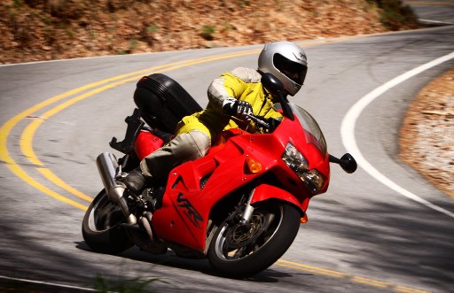
Riding the Great Smoky Mountains and the surrounding area is one for the bucket-list. Five roads in particular stand out and attract riders from all over the world. They are Tail of the Dragon, The Rattler, Devil’s Whip, Diamondback, and The Snake. While each is relatively short, it is hard to find comparable roads that are so highly rideable and pack so many turns per mile. Some would say touring in the Great Smoky Mountains is a master class in technical riding.
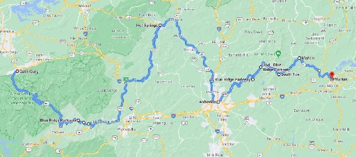
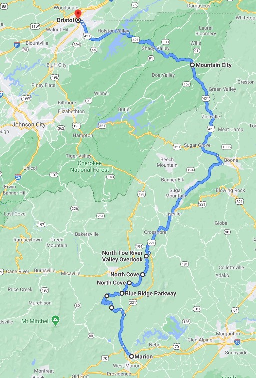
The sheer number of road options can make tour planning a real challenge. We applied a little creativity and plenty of trial and error to work out a route that covers all five of the most popular roads and rides out through the Ridge Region of the Blue Ridge Parkway. This tour delivers four days filled with some of the best riding in America.
When to Ride
Deciding when to take this tour presents two challenges – weather and tourist traffic. The Great Smoky Mountains are a popular summer destination. The National Park Service reports that over 9 million people visit The Great Smoky Mountains National Park each year, twice the next most popular park. Consequently, tourists and traffic in the park and in the Appalachian and Blue Ridge Mountains generally are at their peak between mid-June and mid-August.
Summer temperatures in the area range between the mid-60’s and mid-80’s. The Smoky Mountains have the unfortunate distinction of receiving more annual rainfall, about 85 inches, than any other area in the continental United States. June, July, and August are among the rainiest months. September is typically the driest month; when afternoon showers, while common, occur less frequently.
No one can say for sure what the weather will do or how many people will take to the roads. But historically, touring riders can expect to encounter less traffic in May and September and still enjoy good weather.
What to Expect
Each day covers one or two of the most popular motorcycle roads in the area. Daily riding time runs about 5 hours, allowing plenty of daylight for stops and to take in the incredible sites. Miles per day are well under 300 which considering daily riding time is a testament to just how twisted these roads are. In a nutshell, look forward to twisty roads throughout this tour.
The graphic below gives an idea of where on the route a rider can expect to be at any time, assuming normal gas stops, moderate traffic, and legal speeds. Use the information to decide when to start out each day and to keep track of progress through the day.
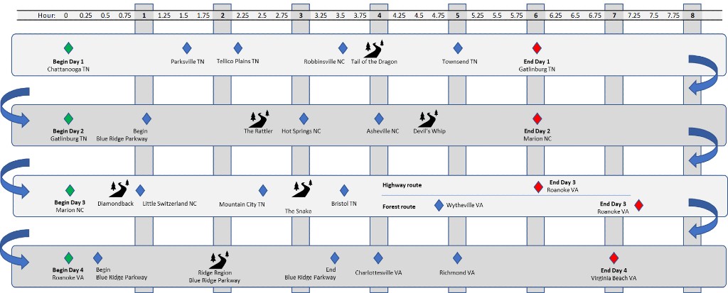
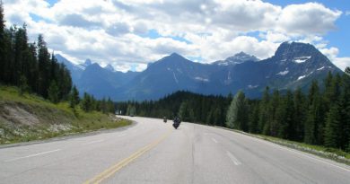
Day 1 – Tail of the Dragon
Plan an early start on the first day of this tour to get the most from a morning ride through the Nantahala National Forest just east of Chattanooga. Use the first 45 unremarkable miles on Interstate 75 toward Parksville TN to anticipate the day. The scenery makes a welcome change as the road passes along Lake Ococee. A twisty section just past the lake helps wake up the reflexes before things slow down again.
If a mid-morning coffee sounds good, then Tellico Plains is worth a stop. The self-styled vintage mountain town of fewer than 1000 residents offers plenty of local coffee shops. Tellico Plains boasts a rich Cherokee history, and in fact derives its name from the Cherokee town of Great Tellico.
Continue east on the Cherohala Skyway deeper into the Nantahala forest. The road begins to throw twists and turns for the next 50 miles into Robbinsville North Carolina. The road surface is well maintained, the curves invite rhythm, and the scenery is filled with chestnut oaks Virginia pines and white pines. Perhaps as a word of caution, Graham County officials point out the highest number of motorcycle crashes in the county happen on this road, not on the Tail of The Dragon.
Take advantage of the many lunch spots in Robbinsville. Grab a bite and top up the tank. The famed Tail of the Dragon is up next.
Tail of the Dragon
From Robbinsville, head north on Tapoco Road (US-129), a gently curving road that leads to the town of Tapoco on the Little Tennessee River. Tapoco is the last waypoint on the south side of the Tail of the Dragon.
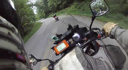
The Tail of the Dragon is an 11 mile stretch of US-129 featuring 318 turns tucked between Tapoco TN and the unincorporated community of Tallassee TN. The North Carolina Department of Transportation estimates over 240,000 riders come every year to test their skills. Motorcycle tourism is a big part of the economy in Graham County; however, emergency services are sparse meaning it can take 30 to 45 minutes for medical help to arrive. And that assumes resources are not already tied up somewhere else.
Bevan Kirley, a research associate at the University of North Carolina Highway Safety Research Center, did a study of motorcycle crashes in Graham County in 2013. Not surprising, she found the most common reason riders crash is because they enter corners too fast. However, more interesting for touring riders, Ms. Kirley found that riders from nearby states are 55% more likely to crash than North Carolina riders and riders from farther away are 91% more likely. Just food for thought, let’s get back to the ride.
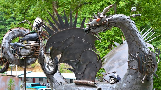
The south end of the Tail of the Dragon begins at Deals Gap NC. Deals Gap has become the gathering place for Dragon riders. The Deals Gap Motorcycle Resort offers accommodations, as well as food and gas, along with an assortment of souvenirs to remember the day. Certainly worth a stop.
The Dragon is the very definition of a “twisty” road, calling for every bit of skill a rider can muster. For tips on riding technical roads, take a look at Riding Tips to Tame a Dragon.
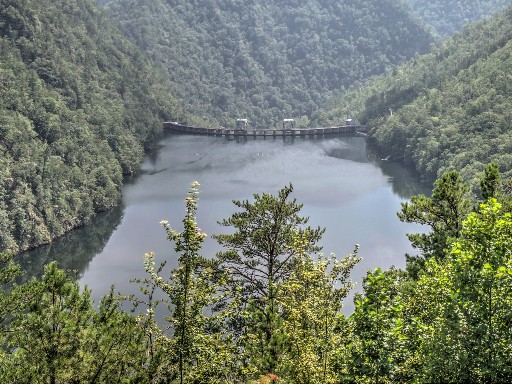
Keep an eye out for the Tail of the Dragon scenic lookout, roughly 8 to 9 miles past Deals Gap. The view to Calderwood Dam below is dramatic. The dam, with Calderwood Lake backing up behind it, is one of 4 dams on the Little Tennessee River built in 1920’s and 30’s to power local aluminum plants. Nearly 100 years later, they’re still in operation under the care of Alcoa (aka Aluminum Company of America). If nothing else, the dramatic view makes a great backdrop for a group shot or a selfie.
On to Gatlinburg
There’s still plenty of good riding left in the day. So gather it up and continue riding US-129 toward Tallassee. The roadway unwinds a bit making the ride a little less exhilarating but compensated for by views of Chilhowee Lake (which covers an ancient Native American village) and more.
Keep an eye out for Foothills Parkway West just past Abrams Creek. The ride turns right onto the parkway toward Gatlinburg. Foothills Parkway is a reasonably quiet two lane road, packed with turns and as a result mostly double yellow for 50+ miles. Not a high-effort road and perfect for afternoon riding.
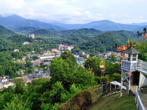
Gatlinburg sits at the entrance to the Great Smoky Mountains National Park. The town has a wide selection of accommodations, restaurants, and entertainment to offer. Check out the suspension bridge at SkyLift Park if time permits.
Day 2 – The Rattler & Devil’s Whip
Day 2 covers two well known motorcycle roads – The Rattler and Devil’s Whip. On top of that, the ride cuts a curvy path through Great Smoky Mountains National Park. It’s worth getting an early start to enjoy the roads, the vistas, and the hospitality that dot the route from beginning to end.
Great Smoky Mountains NP
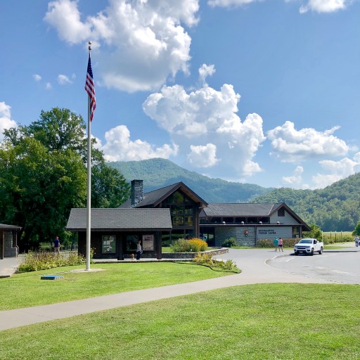
Leave Gatlinburg on US-441 toward Great Smoky Mountains National Park. It’s hard to imagine a better way to start a day of riding than on a well-curved park road, passing through miles of undeveloped American beech and yellow birch forests. The highway twists and turns through the south east edge of Tennessee crossing into North Carolina. Look for the Sugarlands Visitor Center on the north side of the park and The Oconaluftee Visitor Center on the south side. Both have lots of information about the park including exhibits on the history of the Cherokee Indians who originally populated the Great Smoky Mountains.
Coming out of the National Park, look for the Blue Ridge Parkway on the left not too far past the Oconaluftee Visitor Center. This is the south terminus of the Blue Ridge Parkway which extends northward all the way to the Shenandoah National Park. Riding the Blue Ridge Parkway is a tour for another day but this ride picks up another good chunk of it on day 4 between Roanoke VA and the northern terminus near Afton VA.
Follow the Parkway into the Qualla Boundary, a trust land held by the US government for the Eastern Band of Cherokee Indians, and on through treed mountain terrain all the way to the junction with Soco Rd (US-19) at Soco Gap. Consider a stop at the Wheels Through Time Motorcycle Museum just past Maggie Valley.
The Rattler
At Dellwood follow US-276 north to join up with I-40 toward Fines Creek. These uneventful roads offer an opportunity to relax a bit before arriving at the Rattler and Devil’s Whip. Turn off I-40 at Fines Creek Road to Fines Creek and then onto NC-209.
Highway 209 hosts The Rattler’s 10 or so miles of wonderfully twisted road starting at about Spring Creek NC and running up to the town of Hot Springs. Don’t expect the number of turns per mile to match the high standard set by Tail of The Dragon, but still a very likeable bit. The Rattler earned its following with challenging curves, switchbacks, and S-turns but sees fewer riders than the Dragon.
Hot Springs at the other end of the Rattler is a relatively big city for the area and a good place to take a break before riding on to Devil’s Whip.
Devil’s Whip
Things slow down a bit for the next 60 miles from Hot Springs. Head east on US-25 toward Hurricane, and then southeast past Walnut and Weaverville and on to Asheville.
The ride turns north out of Asheville on Elk Mountain Scenic Highway toward Swannanoa. The highway takes on a zig-ziggety pattern as it hugs the hillside giving away views of the surrounding valleys. Pick-up the Blue Ridge Parkway continuing north at Swannanoa. Relax and enjoy riding the Blue Ridge Parkway for another 30 miles or so to the junction with NC-80 where the ride turns south toward Marion NC. This is where Devil’s Whip begins.

Devil’s Whip makes up the next 12 miles of NC-80 toward Marion NC. Another rider’s delight consisting of 160 turns of every combination one could hope for. The party gets off to a fast start with a set of widely spaced rollercoaster-like switchback turns as the road descends. Trees line the way, sometimes shading the entire road with a leafy green canopy. The scenery is fantastic in the moments when one can look away from the road. Eventually, Devil’s Whip mellows out to a simply great motorcycle road. No more switchbacks, just a parade of fast corners made of asphalt in good condition. But don’t get complacent – turns are still sharp and often blind.
The town of Marion comes up a few miles beyond Lake Tahoma, where day 2 of the tour comes to an end. There are a number of reasonable hotels in the area including the big chains and plenty of restaurants and entertainment to fill the evening.
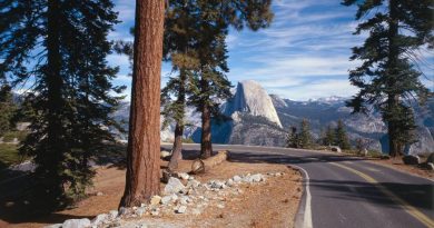
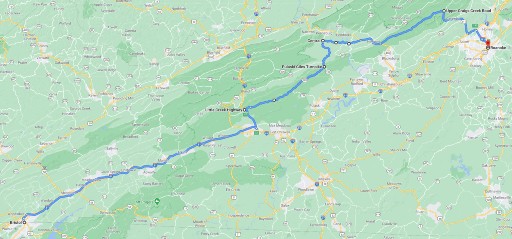
Day 3 – Diamondback & The Snake
So far the ride has covered Tail of The Dragon, The Rattler, and Devil’s Whip. An impressive first two days. Day 3 keeps it going with two more roads that motorcyclists from all over the world seek out. The first part of the day takes on Diamondback in the Blue Ridge Mountains near Little Switzerland. From there, we head over to Mountain City to ride The Snake. The day ends with a relatively quiet ride to Roanoke VA for a rest-up before Tour Day 4.
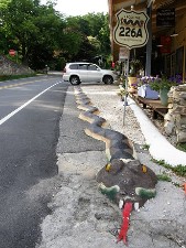
Plan an early start – day 3 is a long one. Grab breakfast, gas-up, and head out of Marion on NC-70 and then connect with NC-221 north toward North Cove. There’s not much to say about the first 8 or 9 miles, except to keep an eye out for the junction with NC-226A just past Woodlawn. Take a left. From here the day gets more interesting.
Diamondback
NC-226A climbs up into the Blue Ridge Mountains, rising more than 2100 feet in just about 11 miles. The section known as Diamondback begins roughly 3 miles past NC-221 and continues for roughly 8 miles to Little Switzerland. The first few miles meander through wooded hillsides, along creeks, and past homes and other buildings here and there. The road itself is in pretty good repair and well marked. Watch for the occasional driveway that may spill gravel onto the roadside.
The last 3 miles of NC-226A rising to about 3500 feet of elevation at Little Switzerland must be where Diamondback earned its name. The road begins a series of sharp hairpins separated by short straights. The valley below becomes visible through the trees as the climb continues. It’s too bad there aren’t more turnouts to stop for a picture.
The Diamondback ride ends in Little Switzerland. Turn off NC-226A at High Ridge Road. The Switzerland Inn on High Ridge Road has good restaurant options and a comfortable patio for a morning coffee break. Follow High Ridge to connect with the Blue Ridge Parkway toward North Cove.
A Scenic Interlude
The route from Diamondback to The Snake incorporates several highways adding up to around 75 riding miles. The first part on the Blue Ridge Parkway is relaxing allowing plenty of time to enjoy this scenic two lane road with occasional overlooks that offer expansive views of the valley below and surrounding mountains. Of course there are still plenty of turns, but a much less strenuous ride.
Turn off the Blue Ridge Parkway at Linville Falls taking US-221 north to the town of Linville. Then pick-up NC-105 out of Linville toward Boone. At Boone, take the bypass to link up with US-321 continuing north and be ready to pretty quickly turn off US-321 onto US-421. The Snake is not far ahead on US-421.
The Snake
The Snake stretches from Mountain City Tennessee to Holston Lake, about 38 miles. The first section from Mountain City crosses over Iron Mountain into Shady Valley. The ride starts in rural farming country and makes its way through hills and over Iron Mountain in a series of wide corners spiced-up with at least a half dozen demanding hairpins.
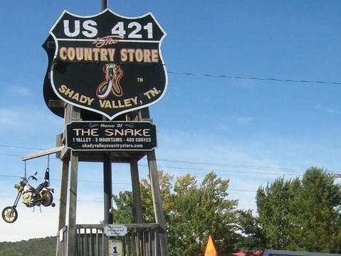
Take a breather through Shady Valley. Maybe stop for a picture under the sign announcing “The Snake” at the country store where US-421 intersects TN-91.
Riding out of Shady Valley leads to more of The Snake. Not so many hairpins in this section, but a mesmerizing sequence of lefts and rights that settle any question about how this road earned its name and why it has such a reputation. Road surfaces are mostly good but with a few rough patches here and there and possibly gravel in a few spots. The Snake more or less ends near the Little Oak Recreation Area.
On to Roanoke VA
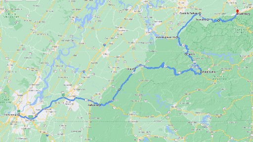
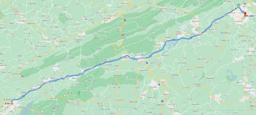
The rest of Day 3 is about enjoying the ride to Roanoke VA for a bit of rest before the last day of the tour. Follow US-421 to Bristol and then take I-81 to Wytheville. At Wytheville, the tour offers a choice to continue riding the highway or jump off to take backroads the rest of the way to Roanoke. The off-highway route follows I-77 to connect with VA-601 and then SR-622. It’s two lane road all the way, mildly curvy, with mostly good pavement although some sections are rough and in need of repair. Plan on 4 hours to Roanoke, compared with 2 hours on Interstate 81.
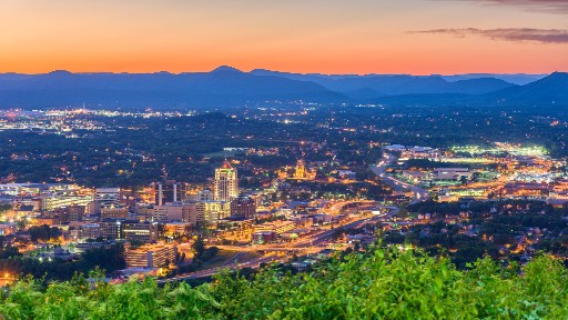
Roanoke is a good size city of over 90,000, located west of the Blue Ridge Mountains. If time allows, take in the local attractions. The Booker T. Washington National Monument is just outside town. If railroading is of interest, check out The Virginia Transportation Museum featuring a collection of railroad exhibits. And for art enthusiast, the Taubman Museum of Art is in the center of town. And of course, there are plenty of hotel and restaurant options as well.
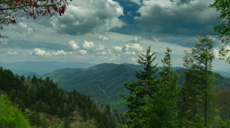
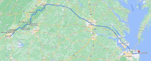
Day 4 – The Blue Ridge Parkway
There are many ways to get from Roanoke to Virginia Beach VA. We’ve come this far riding mostly off-highway through rural communities, national forests and parks and there’s no reason to change now. In fact, Day 4 is intended to celebrate the region with a long ride through the Blue Ridge Mountains before coming to an end on the Atlantic coast at Virginia Beach.
For those who prefer forests over going to the beach, consider riding through the Shenandoah National Park. The route takes Skyline Drive from Afton VA through the park ending at Front Royal VA. It’s just over 100 miles and less than a three hour ride.
Views From The Parkway
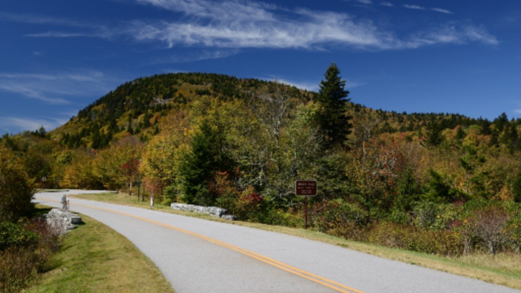
Leave Roanoke on eastbound US-460. Exit onto the Blue Ridge Parkway heading into the George Washington and Jefferson National Forest. This section is known as the Ridge Region, stretching from Roanoke to the Parkway’s northern terminus at Skyline Drive just below the south end of the Shenandoah National Park. Worth a reminder that this tour passed through the southern terminus on Day 2 touching both ends of this 470 mile road through the Appalachian Highlands.
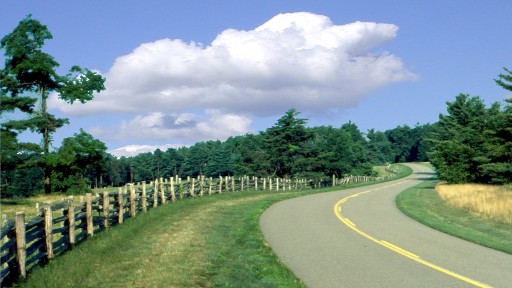
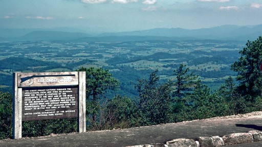
The generally good pavement gently meanders through the wooded landscape. Well marked overlooks offer a break and an opportunity to take in views. Pull outs more or less highlight the best places to enjoy the expansive landscape. With only a narrow grassy shoulder, stopping for pictures anywhere else is not a safe option.
Every overlook has something to offer, but if time allows for only one, make it the Great Valley Overlook. There’s little more than the width of the road rising up from valleys on either side and views that extend to the edge of the earth.
Scenes from the bike and the overlooks more than qualify the Blue Ridge Parkway as a should-ride. But then add the ever-curving road carved along the mountain’s ridge and the Parkway establishes itself as an absolute must-ride.
Life’s a Beach – Snap Out of It
All good things must come to an end, and so it is with the Blue Ridge Parkway. The Parkway reaches its northern terminus at Afton VA. From there the ride turns onto I-64 traveling past Charlottesville, through Richmond, and on to Virginia Beach. That means about 3 hours and 200 miles of riding interstate 64 but it is the best way to make Virginia Beach before dark.
An off-highway route would require an extra day to comfortably reach the coast. But if the monotony of the interstate in the late afternoon becomes too much, consider stopping short at Charlottesville or Richmond.
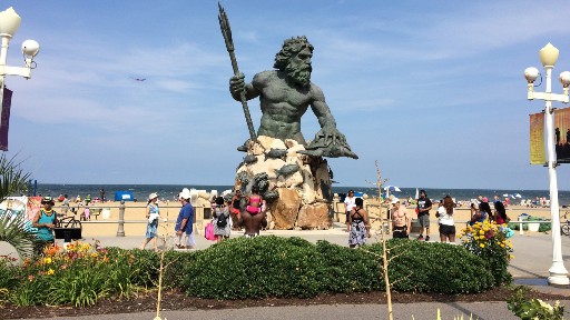
Virginia Beach is the most populated city in Virginia with over 440,000 residents. Located where Chesapeake Bay opens to the Atlantic Ocean, Virginia Beach is a resort town first, but host to a number of large corporations, universities, and military bases. Virginia Beach history is rich with stories from the American Revolution and Civil War as well as more current roles in civil rights and culture.
Our intention was to ride to the Atlantic Ocean and the trip wouldn’t be complete without seeing the ocean close up. Neptune’s Park is a popular place for local events and to kick up some beach sand.
Where to Next
The area where North Carolina and Virginia meet has an abundance of great motorcycle roads. This tour was able to cover five of the best, but there are so many more. It’s a big country. Stay tuned.


Did we hit the mark?
Click the Thumbs Up or Thumbs Down button to email your feedback.
Your questions and comments help improve American Sport Touring. Your email is not used for any other purpose. Please read our Privacy Policy.
Resources
Tour Summary
| Tour Segment | Start At | Ride Miles | Ride Time | End At |
|---|---|---|---|---|
| Day 1 – The Dragon | Chattanooga TN | 230 | 5h 52m | Gatlinburg TN |
| Day 2 – Rattler & Devil’s Whip | Gatlinburg TN | 194 | 5h 31m | Marion NC |
| Day 3 – Diamondback & The Snake | Marion NC | 118 | 3h 6m | Bristol TN |
| Day 3B – Fast Route to Roanoke | Bristol TN | 148 | 2h 19m | Roanoke VA |
| Day 3B – Off-highway to Roanoke | Bristol TN | 177 | 3h 46m | Roanoke VA |
| Day 4 – Blue Ridge Parkway | Roanoke VA | 314 | 6h 6m | Virginia Beach VA |
Useful Links
| Site | Link |
|---|---|
| Great Smoky Mountains National Park information | https://www.nps.gov/grsm/index.htm |
| Blue Ridge Parkway National Park Service information | https://www.nps.gov/blri/index.htm |
| Tennessee DOT traveler information | https://www.tn.gov/tdot/driver-how-do-i/find-traveler-information.html |
| North Carolina DOT traffic & travel information | https://www.ncdot.gov/travel-maps/traffic-travel/Pages/default.aspx |
| Virginia DOT travel information | https://www.virginiadot.org/travel/default.asp |
| About Chattanooga TN | https://www.visitchattanooga.com/ |
| About Gatlinburg TN | https://www.gatlinburg.com/ |
| About Marion NC | https://www.ncblueridge.com/great-little-blue-ridge-towns/a-visitor-guide-to-marion-nc |
| About Roanoke VA | https://www.roanokeva.gov/148/Visiting |
| About Virginia Beach VA | https://www.vbgov.com/visitors/Pages/default.aspx |
| Events at Neptune’s Park Virginia Beach | https://www.neptunefestival.com/events |
| UNC motorcycle crash research study author information | https://www.hsrc.unc.edu/team/kirley/ |