The Ultimate Colorado Motorcycle Tour
Editor’s Note: This article has been updated for the 2026 riding season with current road and national park access information.
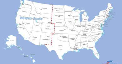
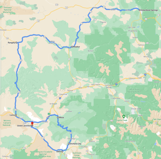
Dream rides are made in Colorado. Vast plains and high desert give way to soaring peaks among the Rocky Mountains, while western towns scattered here and there evoke the best of the past. Colorado has it all. And we want to ride it all. So we got busy and designed an ambitious 9 day, 2400+ mile rider’s ride that traverses alpine mountains, deserts, plains, and deep canyons. The result – a grand loop through the best of Colorado.

Mount Evans Scenic Byway Renamed Mount Blue Sky Scenic Byway Closed Until 2026
Mount Blue Sky (formerly Mount Evans) Scenic Byway is closed between the Forest Service gate at Echo Lake Campground and the summit recreation area. The road will remain closed through Memorial Day weekend 2026. For details, please read Mount Evans Renamed, Closed to Riders until 2026.
Riding in Colorado
Colorado is one of the most rideable states in the union. One can imagine ancient geo-thermal gods gathering to craft a landscape just for motorcycling. The Southern Rocky Mountains are almost entirely in Colorado. Mount Blue Sky and Pikes Peak rise-up in close proximity to each other, luring riders to ascend their paved roads to over 14,000 feet.
One could say that Colorado has two personalities. To the east, The Great Plains roll into Colorado approaching the foothills of the Rocky Mountains just west of Boulder and Denver. Not many will find pleasure riding this side of the state. But starting at the eastern foothills of The Rockies, extending west to the border with neighboring Utah, a more pleasing personality emerges that is a match for any sport touring enthusiast.
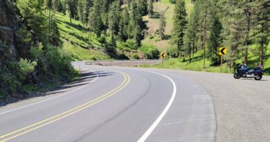
Mountains and forests create both opportunity and obstacles for riders trying to get from one part of the state to another. A glance at the tour route in places may look unnecessarily long. And for anyone on a dual sport, or otherwise happy riding gravel, it may be. Unfortunately, many undeveloped areas are separated by unpaved roads which are not always suited to sport touring bikes. Consequently, the defined route was careful to follow paved roads exclusively.
What to Expect
This tour starts in Grand Junction near the state line with Utah and follows a looping pattern around the western side of Colorado. Riding days are on the long side – it’s a big state – but they always end in a town with ample accommodations and good restaurant choices to enjoy mingling with the locals. Feel free to start the ride at any point on the route or take the ride in either a clockwise or counterclockwise direction.
Temperatures will vary from hot in the lower plains to cool if not downright chilly in the high mountains. And since all of Colorado is at least 1000 feet above sea level, mornings typically start on the cool side even in July and August. Gear-up in layers and plan to peel off one or two as the day goes by. Not everyone may agree, but a heated liner is by far the simplest layer to use – it’s light, easy to pack, and nicely covers any temperature condition. For more on heated gear read The Ins and Outs of Heated Gear.
Daily ride times generally run 5+ hours without considering stops. Plan to start each day as early as possible to get the most from sunlit hours. The scenery on this ride is incredible and packed with picture taking opportunities so naturally stops along the way, not just for food and gas, are a must. After allowing for stops, each day should end by 5 or 5:30pm. That said, this tour puts the emphasis on riding.
Several daily itineraries include destinations that are off the main route. For example, a stop at Mesa Verde National Park on the first day, or rides to the top of Mount Blue Sky and Pikes Peak. These extras are included in the estimated daily ride times and miles; however, if pressed for time they are easy to bypass.
Lastly and not surprisingly, there are other good roads in Colorado not covered by this tour. An unfortunate but necessary compromise to ensure an optimal touring experience. The planned route strikes a balance between road quality, ride miles, and the desire to end each day in a town with decent hotel and restaurant choices.
Day 1 – Grand Junction to Durango via Mesa Verde National Park
Grand Junction is one of the larger towns in Colorado located less than 5 miles from the border with Utah. The name Grand Junction is taken from the confluence of the Gunnison River and Colorado River around which the town was built. The 60,000 residents who make their home here are involved in farming, growing fruit, and cattle ranching. Tourism is also a big help to the local economy.
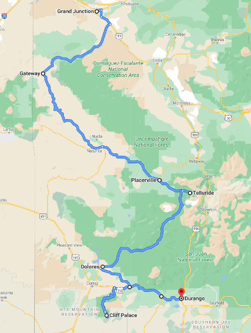
Start day 1 early enough to cover 330 miles and just over 7 hours of riding time that includes stops in Telluride and Mesa Verde National Park before arriving in Durango for the evening. That’s a lot of riding time, mostly a nod to the twisty nature of the roads, in particular the Mesa Verde National Park road.
Leave Grand Junction on US-50 south toward Delta and then connect with CO-141 to Gateway. CO-141 is a quiet two-lane road passing through valleys occupied by cattle ranchers. Monuments along the way call out a few notable landmarks. Past Gateway, where CO-141 crosses the Dolores River, the road takes on a welcome twistiness as it follows the river between canyon walls.

Continue straight through the roundabout on CO-145 just past Placerville toward Telluride about 4 miles up the road. Telluride is one of many well-known ski villages in Colorado. The town has a nice mix of restaurants and coffee shops offering an alpine atmosphere for an early lunch or late coffee.
Leave Telluride returning to the roundabout on CO-145, and this time take the exit toward Rico, continuing on CO-145 all the way to Dolores CO. This is a scenic ride on a well paved 2 lane highway through the San Juan National Forest. Not too twisty, but just right for a relaxing afternoon ride.
The route makes its way between canyon walls along the Dolores River to a small town of the same name, the first example of many western towns to come. Main street has a friendly vibe that fairly reflects the nature of the town’s 1000 residents. Any one of the cafés in Dolores, and pretty much every small town, serves up good food and enough coffee to fuel the day’s ride.
Leaving Dolores, cut over to CO-184 toward Mancos. This is another lightly traveled two-lane road surrounded by ranch land. Mancos marks the junction with US-160 and the need to make a decision about visiting Mesa Verde National Park. A turn to the right, westward on US-160 extends the ride into the park, a left goes directly to Durango.
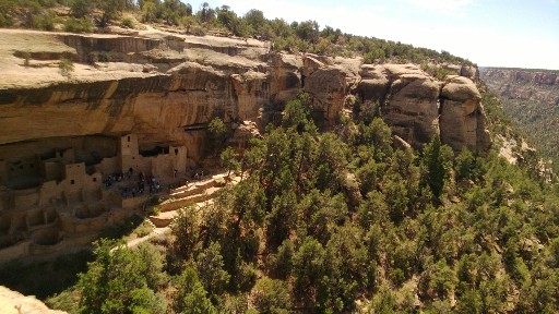
Mesa Verde National Park is known for ancient cave dwellings that were once a thriving Pueblo village. The park preserves thousands of archeological sites including 600 cave dwellings. The road into the park is long and twisty – itself sufficiently entertaining to justify this side trip. Allow 2 hours riding time from Mancos to Mesa Verde and back (about 60 miles). From Manco, Durango is only another 30 minutes or so away.
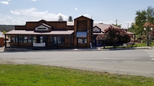
Durango is a relatively large town, together with Grand Junction one of the two most populated on the west side of the state. Everything one needs for a comfortable evening is here. Great hotels, shops, galleries, and of course restaurants and pubs scattered along Durango’s historic Main Avenue and throughout town. A few convenient-to-downtown hotel choices can be found along the Animas River on the west side of town between 5th Street and 11th Street.
Day 2 – Durango to Alamosa on the Million Dollar Highway
Riding Colorado never gets old, and the ride from Durango to Alamosa is just another example why. Plan a long day and consider leaving time at the end of the day for a side trip to the Great Sand Dunes National Park just east of Alamosa.
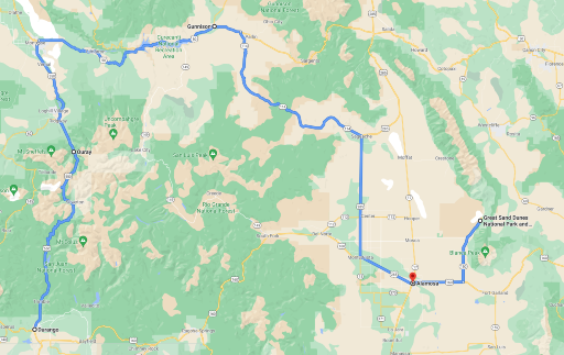
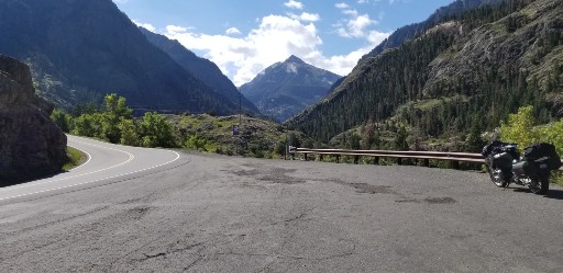
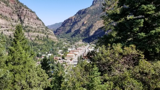
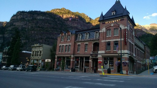
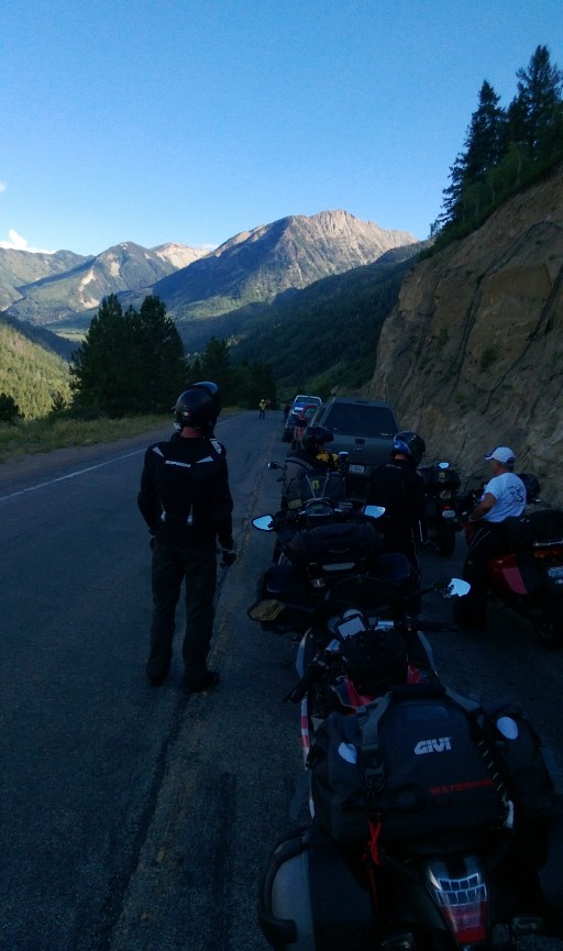
Leave Durango on US-550, also known as The Million Dollar Highway, going north to Ouray. Exactly why it’s called The Million Dollar Highway is up for debate, but the experience riding through canyons formed by the San Juan Mountains is priceless. The town of Ouray itself is a historic district with plenty of well-preserved buildings highlighting its roots as a mining town in the late 1800’s.
Ride out of Ouray on US-550 to Montrose. This section of highway is not quite as twisty, but still scenic. Montrose will feel like riding through urban congestion compared with the first part of the day, but pretty quickly the ride turns onto US-50 heading to Gunnison. Notice the signage pointing to Black Canyon of the Gunnison National Park at the junction with CO-347 – keep riding. We come back to the National Park on Day 4. Today is about making it to Alamosa and an optional side trip to Great Sand Dunes National Park.
The ride on US-50 is scenic showing the landscapes characteristic of western Colorado. Mostly a two-lane highway with occasional passing lanes and other opportunities to get around summertime RVs. Small towns along the way offer refreshments and fuel while others are so small they may escape notice. Just a great road to lose yourself on.
Gunnison is the only large town on the ride today. With a population a little smaller than Durango, it offers plenty of choices for an early afternoon stop. And it’s the last major town before the day ends in Alamosa.
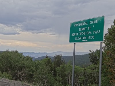
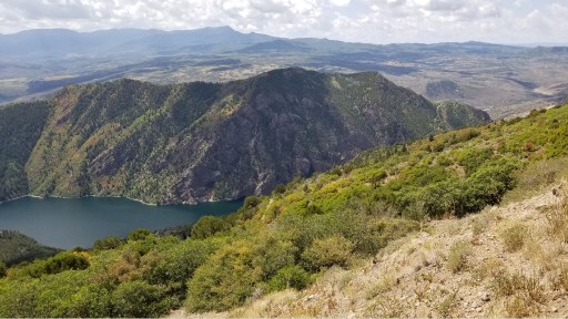
A few miles past Gunnison, look for the junction with CO-114, it’s not well marked. CO-114 is a simple two-lane highway stretching through western Colorado ranchland with panoramic views of the hillsides; one last sort-of twisty bit before Alamosa. The scenery doesn’t let up either. The Continental Divide is notable 35 miles after turning on CO-114. The pull out also marks the summit of North Cochetopa Pass. This is the first of several times this ride crosses the Continental Divide as it traverses Colorado.
The small town of Saguache marks the turn onto US-285 for a more or less direct path to Alamosa where the riding day ends. But for those who left enough time, consider riding on to Great Sand Dunes National Park. It adds another two hours round trip riding time and 100 miles but worth the time to get a glimpse of this national park known for the tallest dunes in North America (which are surf-able by the way).
Day 3 – Alamosa to Gunnison over Slumgullion Pass
Get ready for a long riding day through the best roads in south central(-ish) Colorado, with a brief dip into New Mexico. Highlights include rolling though the Rio Grande National Forest, again crossing the Continental Divide, and cresting the San Juan Mountains by way of Slumgullion Pass (elevation 11,530 ft).
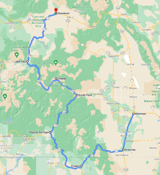
Leave Alamosa on US-285 south to Antonito. Apologies for the next 30 miles of straight road so early in the morning, but a necessary path to connect with CO-17 west into the Rio Grande National Forest. CO-17 is a mountain road featuring good pavement reaching elevations over 10,000 feet with plenty of twisty turns and vista points. Not a technical road, but a good ride.
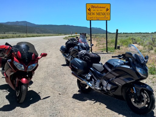
The small town of Chama New Mexico lies about 7 miles south of the Colorado state line in the Southern Rockies at over 7800 feet. The area is popular year-round for outdoor activities. Just past Chama, take US-64 west and then connect with US-84 toward Pagosa Springs to return to Colorado.
The ride from Chama is filled with miles of ranchland stretching to scenic mesas on both sides which in turn lead to the town of Pagosa Springs tucked in the San Juan National Forest. Pagosa Springs has a busy main street with plenty of shops and cafes perfect for a short break.
Follow US-160 out of town toward South Fork. The Rio Grande National Forest closes in around the well maintained mostly two-lane highway as it winds through cattle pastures. Eventually pastures give way to forests as the road continues into the hills passing the Treasure Falls Observation Site. This is not a technical road, but one that patches together strings of sweepers. Some of the best curves are a few miles past the observation site.
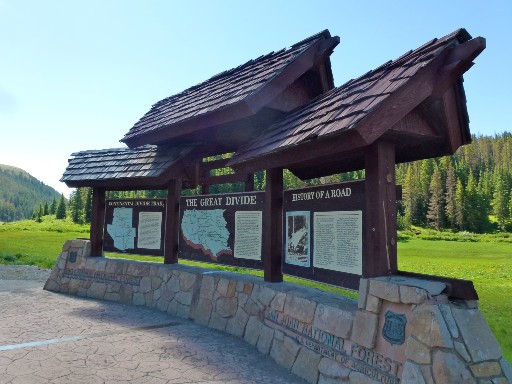
The pull out at Wolf Creek Pass marks the summit at 10,856 feet, and also features a monument marking the point where US-160 crosses the Continental Divide, (the second crossing for those keeping count).
Continue on US-160 as it winds up, down, and through the Rio Grande Forest. At South Fork turn north on CO-149 to Lake City. This stretch of road continues through the Rio Grande National Forest but takes a more twisty path. The landscape is lightly covered by pine trees and native grasses. Catch views of the Rio Grande River running along the road in parts.
The ride from Lake City to Gunnison on CO-149 is a lot more of the same rolling hills and wide sweeping turns. A perfect cool down at the end of the riding day.
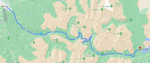
Day 4 – Gunnison to Aspen via Black Canyon of the Gunnison National Park
After three road-full days, day 4 may feel a bit light with just over 5 hours of riding. But start early and use the extra time for to enjoy Black Canyon of the Gunnison National Park.
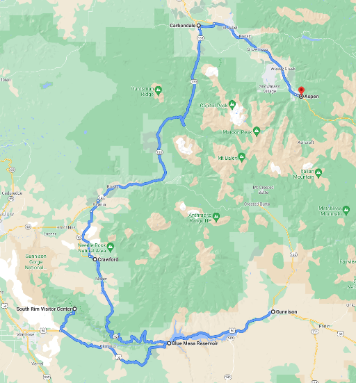
Leave Gunnison on US-50 heading west toward Sapinero. The first 8 miles or so are an unavoidable re-ride up to the junction with CO-149, but all new after that. If a visit to Black Canyon of the Gunnison National Park is of interest, then keep heading west on US-50 toward Cimarron; otherwise turn north toward Crawford on CO-92.
A detour to Black Canyon of the Gunnison National Park adds 80 miles and two hours riding to the day as explained in a moment. Follow US-50 past Cimarron to the junction with CO-347. Turn right to follow CO-347 for 7 miles to the South Rim park site. The South Rim is well developed and the most popular area in the park. A visitor center offers information and restrooms, but there are no restaurants here. As an alternative, the North Rim is accessible from CO-92 (avoiding the extended ride on US-50) and may seem like a more efficient way to visit the park. Unfortunately, this less touristed area also calls for riding 7 miles or so of unpaved road. For those who are OK with that, take Black Canyon Road west off CO-92 a few miles south of Crawford directly to the North Rim.
Back on the main route, head northwest on CO-92 from US-50 less than a mile west of the Gunnison River bridge. CO-92 is an underappreciated 2 lane highway that climbs into the Gunnison National Forest. The first section follows the Gunnison River along the edge of the Black Canyon of the Gunnison revealing striking views of the valleys and canyons along the way.
The small town of Crawford was known for the café that legendary rocker Joe Cocker opened during the years he lived on the Mad Dog Ranch near Crawford. Joe died in 2014 and was buried in the town cemetery across the street from his Café. Unfortunately, the café is no longer in business.
Continue through Crawford and on to Crawford Road toward Paonia and then get on CO-133 toward Carbondale. The next 60 miles on CO-133 are filled with scenery that characterizes western Colorado. The North Fork of the Gunnison river meanders along the roadside separating the ranchlands on the other side. Eventually canyon walls rise and narrow the view. The roadway itself is punctuated with sweeping turns, plenty of passing areas, and the opportunity to make good time. The road does however offer some interesting bits in the higher elevations of the White River National Forest toward Carbondale.
The entrance to the Redstone Historic district is immediately recognizable by the abandoned bee-hive shaped coke ovens that line the highway. These ovens were used to heat coal into coke, a cleaner burning fuel. They are what is left of early Redstone mining operations.
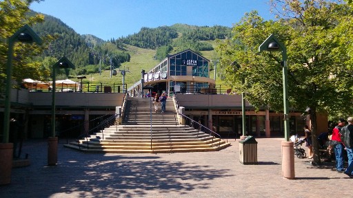
The highway continues its scenic path to Carbondale, a small town with enough amenities for one more afternoon stop. On the other side of town, take CO-82 east to Aspen. Relax a bit and settle in for 4-lane highway riding. This is popular alpine country featuring two major resorts, first Snowmass and then Aspen, with roadways built to accommodate swarms of winter travelers. Summer activities in the mountains are popular too, so comparatively heavy traffic is likely.
The town of Aspen is literally built around ski runs. The lifts terminate in town while the mountain provides a lush green backdrop for outdoor seating at many of the wide range of restaurants and bars. What a great way to end the day!
Day 5 – Aspen to Colorado Springs via Pikes Peak
The air on a summer morning in Aspen is fresh and crisp. Try one of the many coffee houses scattered around town for breakfast, and then get on the road early to allow time for Pikes Peak in the afternoon.
The day starts on CO-82 east through the valley from Aspen Mountain to Twin Lakes. This reasonably twisty two-lane road lined by groves of aspen trees delivers a little bit of everything making for an energizing start to the day. While the first miles are uneventful, the turns get tighter and come one after another as the altitude rises above the tree line to over 12,000 feet at the break between the White River and San Isabel National Forests. In places the road narrows with no shoulder demanding a little extra attention. Pullouts are available here and there to take in views of the surrounding valley and hills. The overlook at Independence Ghost Town is worth a stop. That’s followed by a major pullout, also worth a stop, at Independence Pass which also marks the Continental Divide (the third crossing).
From here there’s no where to go but down, in a good way. And so the ride winds it’s way past remnants of winter snow, around hairpin turns, and past Twin Lakes. At the junction with US-24, turn toward Buena Vista. US-24 follows the Arkansas River. Not a particularly exciting road, albeit scenic in places, US-24 provides an opportunity to relax and maybe make up time.
US-24 becomes US-285 at the small town of Buena Vista. Watch for the junction with US-285 North to Denver. The next 80 miles or so, first on US-285 and then turning onto US-24 at Antero Junction, are best described as easy riding separated by sweeper turns and a backdrop of wide prairies stretching to rolling hills in the distance. Think of it as a way to make highway-speed between Gunnison National Forest and San Isabel National Forest to the east.
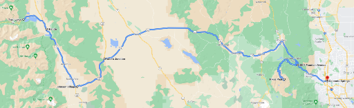
US-24 is largely surrounded by arid ranch land, pastures and rolling hills in the distance. Consider a stop to stretch and gas up in the small town of Hartsel, just past the point where the Middle Fork South Platte River crosses the highway.
Eventually the long stretch of US-24 gives way to the Pike National Forest, the town of Cascade, and then Pikes Peak where upon the road once again develops a personality. At Divide, an honest-to-goodness one stoplight town, the road name changes from US-24 to CO-67. Keep on US-24 through Woodland all the way to Cascade. Watch for the turn onto Pikes Peak Highway North Pole; (probably obvious, but to be sure, North Pole is a Kris Kringle-style tourist attraction at the foot of Pikes Peak).
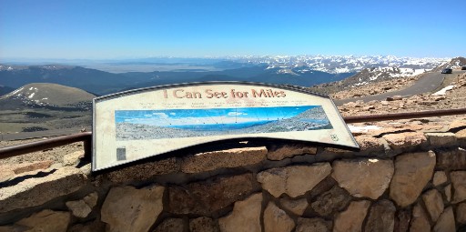
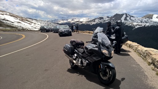
Pikes Peak Highway is the second highest paved road in North America at 14,115 feet. Only the road to the summit of Mount Blue Sky is higher and by a mere 15 feet at that. Find the highway entrance a half mile off US-24 marked by a simple overhead sign. Allow a good two hours from this point to cover the 20 miles to the summit and return. Pikes Peak is not a national park. Admission is required, and during the reservation season riders traveling above Mile 7 must also have a timed-entry permit reservation. Check the Pikes Peak pages of the Colorado Springs city website for current road conditions, reservation requirements, and weather. The new Summit House Visitor Center, opened in early summer 2021, features informative exhibits, a gift store, and dining facilities.
Once past North Pole and after a toll stop, the road twists and turns for miles to the base of Pikes Peak where the real climb begins. The road is well paved but narrow, lined by aspens and pines, and with limited shoulder room in many areas. Mile markers along the way show the elevation. Mile marker 7 indicates the starting point for the famous Pikes Peak International Hillclimb (PPIHC) race which finishes at the summit. Road closures associated with the Pikes Peak International Hill Climb can affect access to the highway, so check the current event schedule before riding.
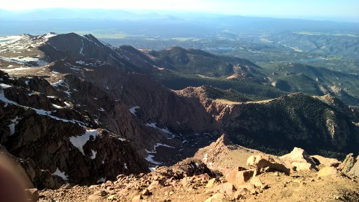
The Pikes Peak Mining Company lodge provides one last opportunity for a break before the final leg to the summit. From here the tree line falls away yielding to rocky patches of mountain grass and expansive views to the horizon. The switchbacks are sharp steeply banked affairs and are sure to intimidate less experienced riders.
After a few self-congratulatory selfies at the summit, head back down to Cascade and then take US-24 into Colorado Springs to wrap-up the day. Unlike Woodland and Cascade, Colorado Springs has an abundance of hotel choices and nightlife. But if hotel and restaurant choices aren’t important and the extra 30 minutes to Colorado Springs matter more, then there are a few motels available in Woodland. Either way, Day 6 comes back through Woodland to head north toward Estes Park.
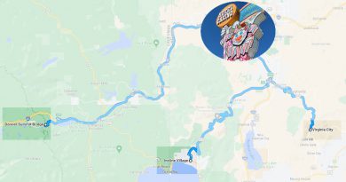
Day 6 – Colorado Springs to Estes Park via Mount Blue Sky
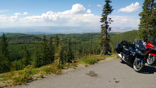
The sixth riding day in Colorado runs through the Pike National Forest and into the San Isabel Forest, on to Mount Blue Sky, and then to Estes Park in the Arapaho National Forest to end the day. Be ready for another long day filled with memorable roads and a ride to the summit of Mount Blue Sky.
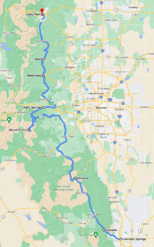
Leave Colorado Springs and head back to Woodland Park where the ride turns onto CO-67 North. CO-67 may feel like a straight road after Pikes Peak, but it’s a perfect start to the day as it rolls and sweeps through forested hills and valleys. An occasional series of 30MPH corners keep it interesting.
At the intersection with US-285 take a right (east) toward Conifer where the route turns onto County Road 73 North. At Evergreen, jump over to CO-74, still going North. Both the County Road and CO-74 are nicely paved and relatively quiet 2 laners with plenty of Colorado ranchland scenery and picturesque towns along the way.
At the intersection with CO-103, turn left to follow this gently curving road west to connect with Mount Blue Sky Road. Echo Lake Lodge sits prominently at the intersection offering the only stop for refreshments in the area. Mount Blue Sky does not have a visitor center or amenities of any kind at the summit. A timed-entry reservation is required for entry to the Mount Blue Sky Recreation Area during the operating season, and standard recreation fees also apply. Visitors should secure reservations in advance through Recreation.gov and check current access details before riding.
The road to the summit is reasonably well paved with narrow shoulders or none at all in many places. It starts calmly, but gradually dials up the turns to eleven. The same cautions apply here as on Pikes Peak – the climb is steep and the switchbacks near the summit may intimidate inexperienced riders. That said, this is a ride one won’t soon forget. Take a look at the article Mount Blue Sky by Motorcycle for more about what to expect.
Head back down from the summit and re-connect with CO-103 at Echo Lake Lodge. Remember to pick up a souvenir at the lodge before heading toward Idaho Springs. CO-103 continues to throw some pretty aggressive twists for the first 5 miles or so before settling down to a fun country road entering Idaho Springs. Top up the tank and take a break at one of the cafes in town before riding on. Leave town on I-70 east for about 5 miles and then jump on US-6.
Look for the junction with CO-119 North to begin riding the Peak to Peak Highway. This scenic byway runs through the Arapaho and Roosevelt National Forest past Nederland, Ward, and Allenspark before ending in Estes Park. These roads are all well paved and offer a mix of turns sure to end the day with a smile.
The town of Estes Park, known as the gateway to Rocky Mountain National Park has much to offer. Head toward picturesque W. Elkhorn Avenue/E. Elkhorn Avenue between West Drive and Virginia Drive to experience local restaurants, bars, and shops.
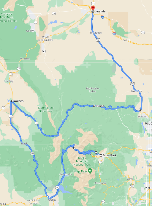
Day 7 – Estes Park to Laramie via Rocky Mountain National Park
Estes Park on a summer morning is a special place where chilled mountain air mixes with the aroma of fresh hot coffee at an outdoor café. Throw in anticipation of full day riding in the Rockies and the excitement is hard to contain. Leave Estes Park early to make the most of the day and allow time for stops here and there. The roads ahead are complex and scenic at the same time.
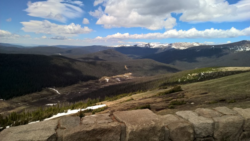
Take US-34 out of Estes Park directly into Rocky Mountain National Park. An entrance fee or America the Beautiful pass is required to enter Rocky Mountain National Park. During the timed-entry season, riders entering during regulated hours must also have a timed-entry reservation. Once inside, simply stay on US-34 through the entire length of the park to enjoy the best views and access to amenities. Consider a stop at the Fall River Visitor Center, not far from the entrance, to pick-up information about current activities. Be aware that gas is not available in the park and cell service is spotty at best.
The roads are crowded during the summer months and have few passing zones. Fortunately, there are plenty of pullouts and vista points throughout the park. Riding high into the Rockies, above 12,000 feet, the boulders and alpine grass that surround the road fall away steeply into forested valleys far below. The experience of riding here will inspire the environmentalist in even the most hardcore urbanite. Stop at the Alpine Visitor Center, the highest in the National Park system at 11,796 feet, to discover interesting facts about the high terrain, grab a snack, or simply take a break.
Within a couple miles, US-34 descends once again below the tree line into forest land and continues to the western park entrance and the Kawuneeche Visitor Center just beyond that.
At Granby, take US-40 west past Windy Gap Reservoir. Then turn onto CO-125 north to Walden. The landscape transitions to cattle country and aspen groves. A quiet ride before turning back into the Rockies once again.
Gas up in Walden and then take the junction with CO-14 eastbound toward the Rocky Mountains on the horizon. This part of the ride side-steps Rocky Mountain National Park to the north passing through State Park state park (that’s right, a park named “State Park”). The Moose Visitor Center in Gould has lots of information to share about wildlife in the area.
CO-14never becomes a complex twisty road, but it will entertain with periodic S-curves, sweepers, flowing rivers, and beautiful forest and canyon views. Services in the area are sparse, so mind the tank.
Eventually the canyons give way to open terrain and CO-14 meets US-287 where the ride turns north. Grasslands and occasional slight turns characterize the next 50 miles on US-287 into Laramie WY where the day comes to an end.
Laramie is a reasonably good size city with over 32,000 residents. The town carries an oversized western reputation mostly due to numerous movies and TV shows set in or about the city. The University of Wyoming is also located here which creates a strong economic base for local hotels and restaurants.
Day 8 – Laramie to Steamboat Springs over Battle Pass
Grab coffee and gas up before riding out of Laramie on WY-130 westbound. Some of the best coffee shops are in the center of town on the south side of the university.
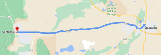
Don’t be discouraged by WY-130’s relative straightness to Centennial WY. After Centennial, WY-130 becomes the Snowy Range Scenic Byway climbing to Snowy Range Pass in the Medicine Bow National Forest. Unlike Colorado, the highway in Wyoming features ponderosa pines in the lower elevations and spruce and fir trees at higher elevations.
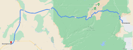
Make a stop at the rustic Libby Flats observation point. From the stone observation platform, one can see Rocky Mountain National Park to the south, and to the west Medicine Bow Peak and the Sierra Madre Mountains.
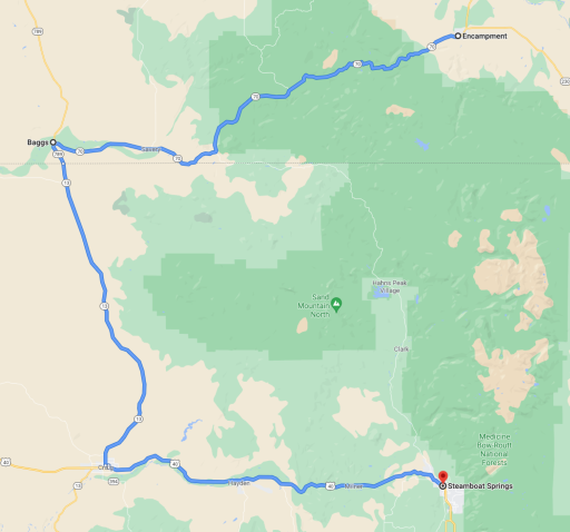
Eventually WY-130 comes to an end at the junction with WY-230 where the ride turns south to Riverside and Encampment. More miles through open prairies. First to Riverside where WY-230 transitions to WY-70, and then through neighboring Encampment and on to even more prairie land after that. But don’t despair, the Battle Pass Scenic Byway section of WY-70 over the Sierra Madre Mountains of Wyoming offers plenty of turns and views of the surrounding Medicine Bow National Forest. The Scenic Byway continues its ascent to Battle Pass and the Continental Divide (for the fourth and final time) at 9,915 feet and then starts a long and twisty descent out of the National Forest.
The remainder of WY-70 into Baggs passes through rolling hills and patches of sage brush. The roadway takes a turn here and there making it a somewhat better ride than many connector roads, (where “connector road” refers to an interlude between true motorcycle roads).
Turn south at Baggs on WY-789 south to Craig Colorado; the road name changes to CO-13 at the state line. Not much to say about this road. It’s a long mostly straight two-lane highway through rolling hills and pastures.
Steamboat Springs is less than an hour away from Craig on US-40 east. The surrounding cattle, wheat, and hay farms provide scenery while the road loosely follows the Yampa River. Hayden Station, a coal-fired power plant that will begin shutting down in 2027, appears on the horizon. Past Hayden, the road begins a pattern of sweeper turns all the way into Steamboat Springs.
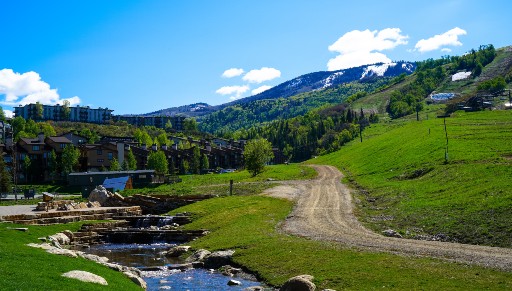
Steamboat Springs took its name in the 1800s from a single hot spring, not surprisingly, called Steamboat Spring. That hot spring is still active in the center of town. With a population of over 25,000 residents and a robust outdoor lifestyle, Steamboat Springs offers plenty of hotel and restaurant choices.
The ride into town from the west passes through the old downtown area made up of restaurants, bars, and shops. However, the majority of hotel choices are on the east side of town near Steamboat Ski Resort. Keep the ski village in mind for coffee before leaving town in the morning.
Day 9 – Back to Grand Junction via Grand Mesa National Forest
And finally, the last day of the ultimate Colorado ride. Look forward to more rolling hills surrounded by farmland and pastureland. The day culminates with a ride along the picturesque Grand Mesa Scenic Byway before coming to a close where it started in Grand Junction.
Leave Steamboat Springs westward toward Hayden, re-riding (unavoidably) 40 miles of US-40 back to Craig. On the west side of Craig, turn south on CO-13. Soon the two-lane highway opens to green farmland, views of the Yampa River and then Williams Fork, all wrapped in easy sweeping turns. For Colorado, these lowlands, at a relatively modest 6100 feet, stretch uninterrupted to the horizon on all sides. The morning freshness is intoxicating.
A couple miles past Meeker turn onto CO-64 to continue west. More farms, ranches, and wide sweepers. Eventually the White River appears. The river carves a path along the roadside offering a new visual element to the canonical western landscape.
The town of Rangely marks the point where the ride turns south onto CO-139. Gas and a few restaurant choices are available in town. The ride out of Rangely is uneventful and stays that way for a good number of miles. But then what started slowly, builds into a pretty interesting road. The best parts are about 20 miles from Rangely, in the area of Douglass Pass in the Book Cliffs Mountains. The hills close in forcing the road to weave its way through. Eventually fir trees cover the hills and that familiar feeling of riding a mountain road returns, while see-through s-curves add personality. The climb reaches an elevation over 8,250 feet at Douglass Pass. The pass is recognizable by a cattle grate and radio tower installation located in an unusually large pullout. If not for those landmarks, one would very likely ride right past this scenic overlook. On a clear day the La Sal Mountains in Utah are visible to the southwest.
Coming down from the pass to the south is a steep ride arguably better than the ascent. The scenery is classic mountain vista and the turns are well spaced and in sections allow visibility from one to the next. Adrenaline levels drop-off as CO-139 winds through the surrounding valleys, but no one is likely to get bored with the frequent sweeping turns. And yes, there are some soulless sections of straight desert road to work through. A little bad with the good.
At Loma connect with I-70 eastbound. This short hop on the interstate, along the Colorado River, bypasses Grand Junction and instead exits 20 miles later onto CO-65 South Grand Mesa to ride the Grand Mesa National and Historic Scenic Byway southbound.
Make a quick stop at the informative pullout not far down CO-65 and then enjoy the next 55 miles to Orchard City. The area is filled with recreation sites of all kinds from skiing to fishing all packaged in natural beauty. The aptly named Grand Mesa is the largest flat-top mountain (aka “mesa”) in the world. The road through the National Forest atop this mesa at 10,500 feet offers one more chance to enjoy views from the high mountains of Colorado.
After leaving the National Forest, the roadway straightens out considerably as it makes its way to Cedaredge and then on to Orchard City. From there continue on CO-65 to the junction with CO-92 where the ride turns west to connect with US-50 at Delta. Unwind for the next 50 miles back to Grand Junction where this 9-day rides ends.
Colorado – So Much More Than The Rockies
Riding Colorado yields strikingly different experiences, from traversing the highest peaks in North America to trekking through arid desert to visit cave dwellings. This tour was optimized to bring together the best roads and most remarkable destinations Colorado has to offer while avoiding unpaved roads and minimizing the need to re-ride an area.
No mistaking The Ultimate Colorado Motorcycle Ride is ambitious even for experienced motorcyclist but one that will leave long lasting memories of incredible roads through areas of stunning natural beauty. The numbers tell the story…
- Summitted the #1 and #2 highest paved roads in North America;
- Crossed the Continental Divide in 4 distinct places;
- Rode 8 National Forests;
- Visited 4 National Parks;
- Rode highways and byways in 3 states;
- Covered approximately 2490 planned miles;
- All in 9 amazing days
So where to next? That’s not an easy question to answer with so many good choices within reach of Grand Junction. Start with the national parks in Utah. Arches and Canyonlands are not far across the state line. Then there’s Grand Tetons National Park and Yellowstone National Park up north in Wyoming. The Black Hills, Deadwood, and Sturgis are not too far to the east through Wyoming as well. Looking south past Utah, the Grand Canyon is a must-see, particularly from the less-touristy North Rim. The options go on and on; why stop?
Share Your Thoughts
Thank you for your feedback!
Please email the editor with any additional comments.
Your feedback is used only by American Sport Touring. We do not store or sell your information.
Please read our Privacy Policy.

by John DeVitis, Editor and Publisher
John DeVitis, Editor & Publisher of American Sport Touring, has spent years riding and writing with a focus on long-distance, performance-oriented motorcycling. His time on the road has revealed little-known routes across the United States and Canada, along with practical insights into the bikes, gear, and techniques that matter to sport touring riders. He draws on this experience, together with a background in digital publishing, to guide the editorial principles and clear vision behind American Sport Touring, delivering content riders can trust.
Resources
Tour Summary
| Segment | Start At | Ride Miles | Ride Time | End At |
|---|---|---|---|---|
| Day 1 – Mesa Verde NP | Grand Junction CO | 330 | 7h 12m | Durango CO |
| Day 2 – Million Dollar Highway | Durango CO | 362 (419 if taking the US-50 detour) | 7h 12m (8h 29m with the detour) | Alamosa CO |
| Day 3 – Slumguillion Pass | Alamosa CO | 296 | 6h 2m | Gunnison CO |
| Day 4 – Black Canyon of the Gunnison NP | Gunnison CO | 246 | 5h 24m | Aspen CO |
| Day 5 – Pikes Peak | Aspen CO | 199 | 5h 18m | Colorado Springs CO |
| Day 6 – Mount Blue Sky & Peak to Peak Hwy | Colorado Springs CO | 222 | 6h 15m | Estes Park CO |
| Day 7 – Rocky Mountain NP | Estes Park CO | 261 | 5h 48m | Laramie WY |
| Day 8 – Snowy Range & Battle Pass | Laramie WY | 222 | 4h 39m | Steamboat Springs CO |
| Day 9 – Grand Mesa National Forest | Steamboat Springs CO | 357 | 6h 33m | Grand Junction CO |