Ride the Apache Trail in Arizona
Arizona, known for its vast deserts, iconic cacti, and stunning landscapes, offers motorcyclists an unforgettable journey along the historic Apache Trail. This scenic route through the Sonora Desert, passing through the Superstition Mountains, is filled with breathtaking views, winding roads, and unique attractions along the way.
About the Apache Trail
Native American tribes, particularly the Apache, carved out the Apache Trail in the early 20th century as a footpath through the Superstition Mountains. Later it gained significance as a supply route during construction of Roosevelt Dam on the Salt River in the early 1900s. After completing the dam in 1911, highway engineers created a more accessible roadway, Arizona State Route 88, but still retaining the name Apache Trail.
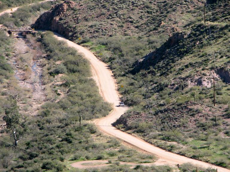
A good part of the Apache Trail is unpaved. The section that begins at a vista point roughly 25 miles east of Apache Junction and continues east all the way to the Theodore Roosevelt Dam Overlook is 21 miles of dirt road. Crossovers and adventure bikes won’t have a problem, but sport touring bikes may find the ride challenging. To be sure, an experienced rider on just about any bike can handle the road – if they want to.
In its present partially unpaved state, the Apache Trail continues to attract and awe motorcyclists from all over the country with its breathtaking scenery, winding roadway, and comfortable spring and fall riding weather.
The Apache Trail is an historic destination road worth working into a longer route plan.
When to Ride
Plan a ride in the early spring before May or late in the fall after September when temperatures are reliably in the mid-70’s and the chance of rain is low. Winter temperatures, particularly in the mountainous parts of the Trail, can dip below 50 degrees and snow may occasionally fall in the higher elevations. Summer temperatures on the other hand often soar well above 100 degrees.
Always check the weather. Some days it may pay to ride early or start out later to avoid the midday heat.
The Route
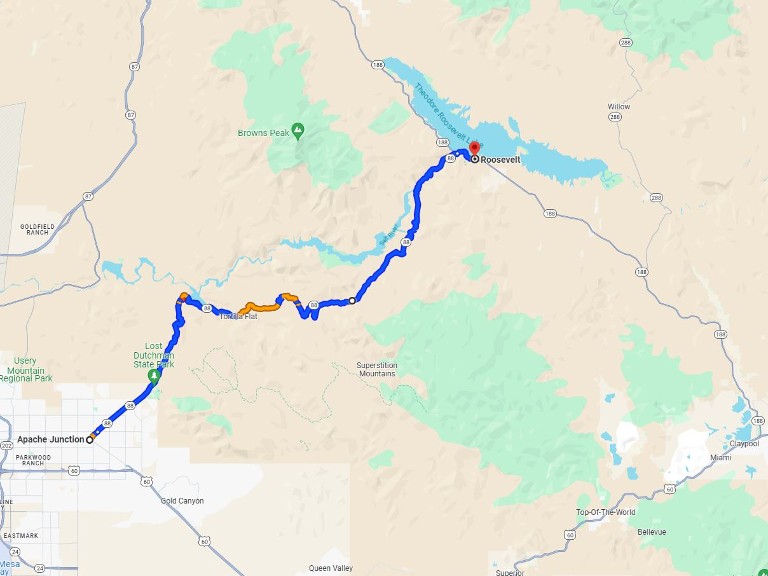
The Apache Trail, Arizona State Route 88, extends from Mesa Arizona to the Theodore Roosevelt Dam 64 miles to the east. The scenery along the way is extraordinary. But keep in mind the pavement ends after the first 25 miles beyond Apache Junction.

Be sure to top up your tank before heading out. The route is not that long, but you won’t find any gas stations along the way either. And since the area is remote, it’s a good idea to pack along drinking water too.
Mesa Arizona
Start this ride in Mesa, located just a dozen miles east of Phoenix. Spend a day exploring this vibrant city filled with local art galleries and a diverse mix of restaurants. The next morning, gear up and head east through Apache Junction and into the Superstition Mountains on Highway 88.
Through the Superstition Mountains
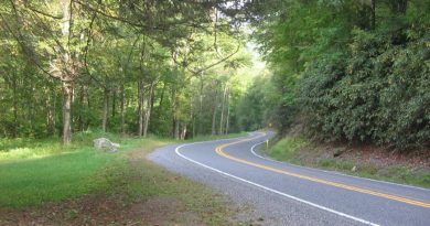
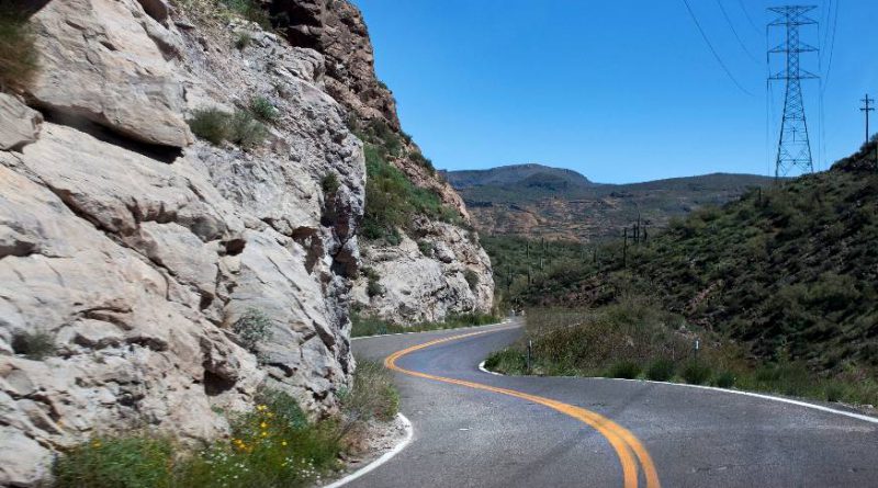
As you leave the urban landscape behind, the road begins to wind through the rugged beauty of the Tonto National Forest and surrounding Superstition Mountains. The Apache Trail is not just a road; it’s an experience that immerses riders in the raw, untouched landscape of Arizona. The twists and turns of the road are a motorcyclist’s dream, offering both challenges and thrills against a backdrop of awe-inspiring scenery.
Goldfield Ghost Town
Soon after leaving Apache Junction eastbound, you’ll encounter Goldfield Ghost Town. This well-preserved town gives riders a glimpse into Arizona’s gold mining history. Explore the historic buildings, wander through the museum, and perhaps even try your luck at gold panning. The town’s Wild West atmosphere is enhanced by costumed actors, creating an immersive experience that transports visitors back in time.
Yes it’s touristy, but worth a stop.
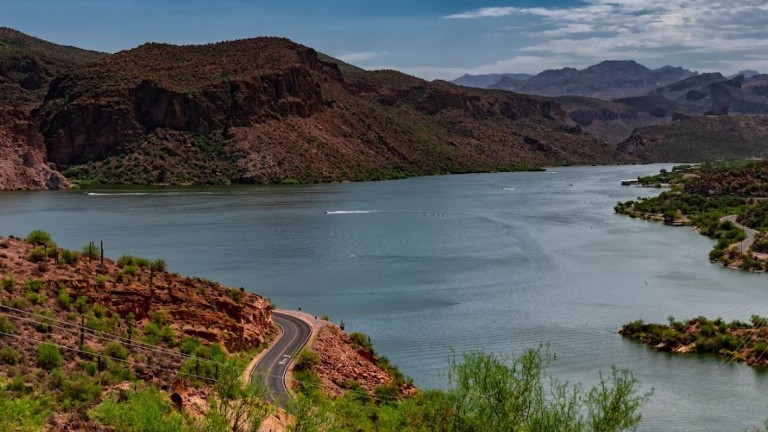
Canyon Lake
One of the first highlights along the Apache Trail is Canyon Lake. Nestled amidst the mountains, this picturesque reservoir is a haven for water enthusiasts. Pull over, take a break, and soak in the tranquility of the lake. The crystal-clear waters, surrounded by rocky cliffs and desert vegetation, create a stunning contrast that’s perfect for capturing memorable photos.
Tortilla Flat
A short ride from Canyon Lake brings you to Tortilla Flat, a quirky but charming outpost with a population of six, literally six, residents. This tiny town, with its wooden buildings and rustic charm, is a throwback to the Old West. Stop at the famous Tortilla Flat Restaurant for a hearty meal and explore the historic saloon, gift shop, and museum. The walls are adorned with dollar bills signed by visitors, adding a unique touch to this remote stopover.
The Challenging Sections
As you continue riding east from Tortilla Flat get ready for the most challenging part of the Apache Trail. The road becomes narrow, with hairpin turns and steep drop-offs. Eventually a road sign announces that the pavement ends in 500 feet. From that point, and for the next 21 miles, the road surface turns to clay. Sections become narrow, not much wider than a single lane. But this is still a legitimate road with most of the usual advisory signage; for example “curves ahead” and “watch for trucks”. Even so, you don’t want to break down out here.
Completing this last section to Roosevelt Dam is a real test of your riding skills but just as importantly an opportunity to connect with the untamed beauty of the Superstition Mountains.
Spectacular Desert Scenery
As you ride further along the Apache Trail, the desert scenery unfolds in all its glory. Saguaro cacti stand tall against the backdrop of the mountains, and the vast expanse of the Sonoran Desert stretches out before you. The changing colors of the landscape, especially during sunrise or sunset, add a magical touch to your journey. Take advantage of the numerous viewpoints along the trail to pause and enjoy the beauty of the Arizona desert.
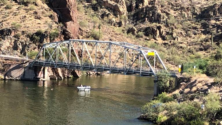
Theodore Roosevelt Dam
The Apache Trail leads you to the impressive Theodore Roosevelt Dam, a marvel of engineering nestled within the rugged terrain. Make a stop at the overlook, located about where the pavement once again resumes, for impressive views of the spillway and power station below. A second vista point just before the junction with Arizona State Route 188 offers views of Lake Roosevelt. The lake’s calm waters framed under the arch of the SR-188 bridge, create a stark contrast with the surrounding desert rocks.
Bring it Back to Mesa
Some riders may want to double back and experience this scenic road in both directions. But for those who don’t there are two options. Either take Arizona State Route 188 south to Globe or head north toward the junction with SR-87. Both will take you past gas stations and have you in Mesa before the day ends.
Quintessentially Southwestern
A motorcycle ride on the Apache Trail in Arizona is more than a journey; it’s an immersion into the diverse and stunning landscapes that define this southwest state. From the challenging twists of the mountain roads to the serene beauty of lakes and deserts, every mile offers a unique experience. Whether you’re a seasoned rider seeking diverse riding conditions, or a committed sport touring enthusiast in search of breathtaking views, the Apache Trail is a must-ride destination that captures the essence of Arizona’s untamed beauty.


Did we hit the mark?
Click the Thumbs Up or Thumbs Down button to email your feedback.
Your questions and comments help improve American Sport Touring. Your email is not used for any other purpose. Please read our Privacy Policy.